Scholasticide in Gaza: The Targeting of UNRWA Schools
Editor's Note: This is one of several open-source intelligence (OSINT) investigations conducted by the NAWA Media Open-Source Investigations Team in collaboration with journalists at The Public Source. These reports were produced in October and November of last year; due to the rapidly escalating violence, the figures are a historical record of that time rather than a reflection of the current reality. Through these reports, we aim to contribute to the growing body of evidence of war crimes and crimes against humanity committed by Israel in its war against the Palestinian people in Gaza. For this reason, the authors of these investigations use precise and cautious language that helps in advancing the prosecution of these crimes in international courts.
As of November 23, 2023, more than 14,800 Palestinians had been killed in Gaza, including over 6,000 children, according to the Palestinian Government Media Office. Between October 7 and October 27, 2023, over 200 school buildings were damaged in the Gaza Strip, 40 of them severely, according to UNICEF data. This amounts to 40 percent of all school buildings in Gaza. This is scholasticide — coined by Karma Nabulsi — or the “systematic destruction of Palestinian education by Israel.”
Displaced Palestinians are using school buildings as safety shelters. The United Nations Relief and Works Agency for Palestine Refugees (UNRWA) estimated at the beginning of November (when this investigation was conducted) that it was hosting around 700,000 people in its various buildings since October 7. Twenty-five of these school shelters are located in northern Gaza and host 112,000 people; some of these schools were directly targeted and others were damaged in nearby attacks.
This is an investigation around four attacks on four UNRWA schools in the northern Gaza Strip in early November 2023. These attacks took place on November 2, 3, and 4, causing many casualties.
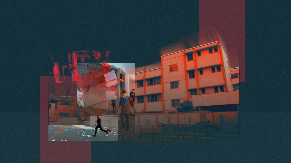
Al-Shati’ Preparatory School for Refugee Boys, also known as “Abu Assi School”
On November 2, 2023, at 08:23 Gaza City time, Al Jazeera Palestine published a post on X (formerly Twitter) reporting that five people were killed and others were injured during an Israeli bombing that targeted the vicinity of an UNRWA school in al-Shati’ Camp in western Gaza. Earlier that morning, at 07:54, X user Mahmoud Miqdad reported that “Abu Assi school,” which shelters thousands of displaced people west of Gaza City, was bombed.
About an hour later, at 06:53:49 UTC, which is 08:53 Gaza City time, journalist Ahmed Hijazi posted a video “reel” on his Instagram page, reporting that the UNRWA school in al-Shati’ Camp was attacked with white phosphorus bombs. Hijazi then posted a series of videos as a “story” on his Instagram page, which later circulated on X.
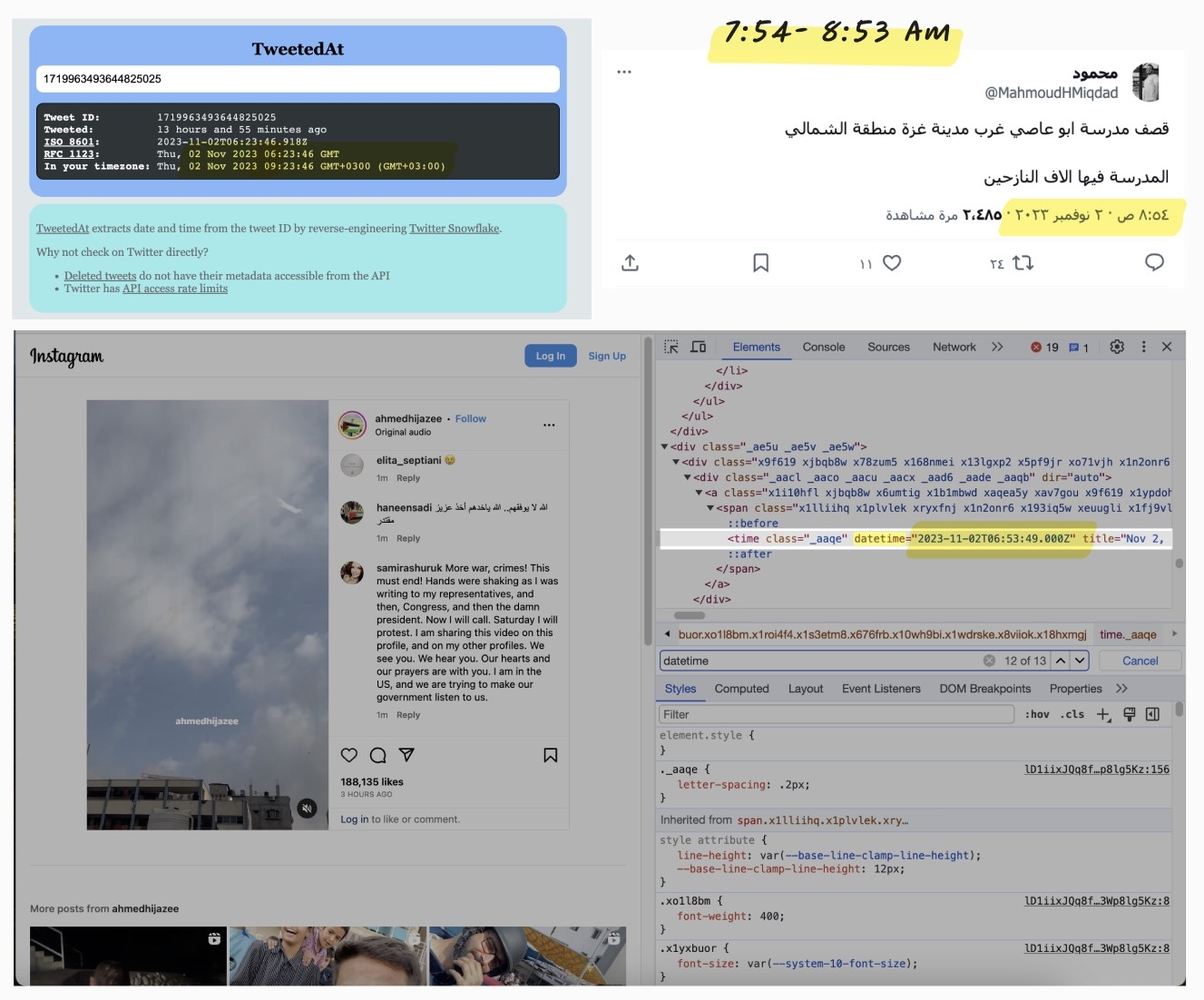
Top left: Image documentation from the tool TweetedAt showing Al Jazeera Palestine’s post on X. Top right: A screenshot of Mahmoud Miqdad’s post on X. Below: Image documentation showing a time analysis of the video that journalist Ahmed Hijazi published on Instagram.
In the published videos, Hijazi documented the successive shelling of the UNRWA school in al-Shati’ Camp and the surrounding area in the northern Gaza Strip. He claimed that artillery shells and white phosphorus bombs were used. It is worth noting that the rising smoke from the shelling made it difficult to determine the exact time of the attack through shadow analysis. However, a possible time of the attack is between 07:54, the time when the news was first reported, and 08:53, when a video documenting the attack was published.
Geographic Location
The search for the location began with keywords such as “al-Shati’ School” and “Abu Assi School.” We then matched the visuals with elements from journalist Ahmed Hijazi’s video that he posted on Instagram as a story on November 2, 2023. By doing so, it was possible to determine the geographic location of al-Shati’ Preparatory School for Refugee Boys, known as the “Abu Assi school” in al-Shati’ camp in the Gaza Strip, at the coordinates 31.537304, 34.449559.
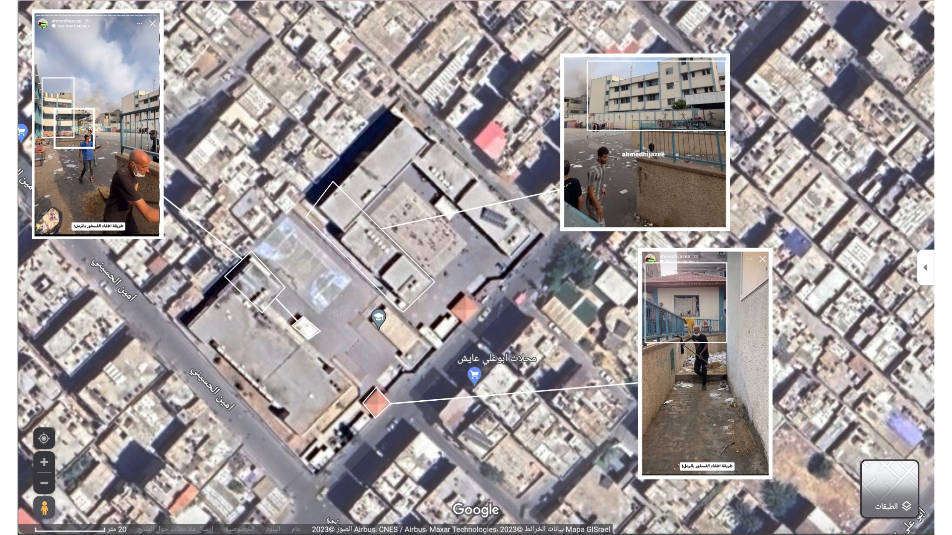
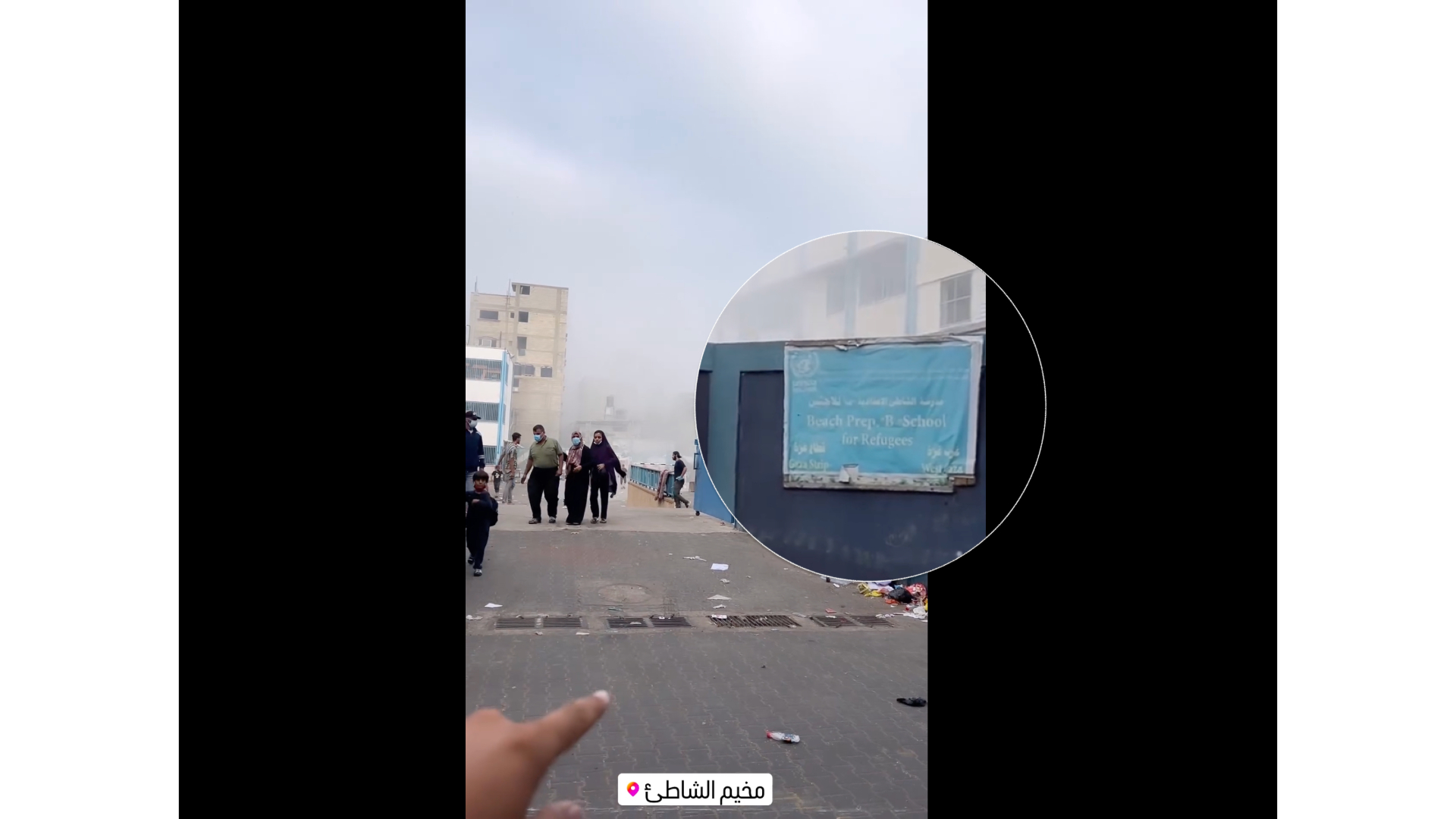
Comparison: Screenshot from satellite images of al-Shati’ Preparatory School for Refugee Boys on Google Maps and stills from journalist Ahmed Hijazi’s video on Instagram. November 2023.
Smoke Phosphorus Attacks
The series of videos that Hijazi shared shows a number of shells, falling within seconds from one another. The Israeli army deployed smoke bombs and phosphorus bombs in the attack. Some of these bombs fell on the buildings of the UNRWA school, its courtyard, and on houses adjacent to the school.
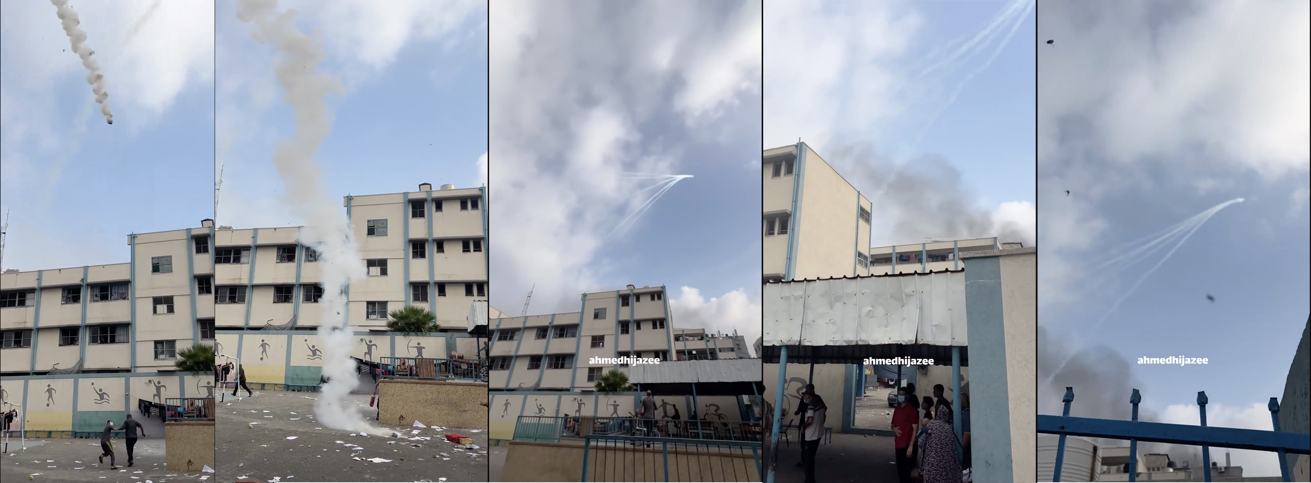
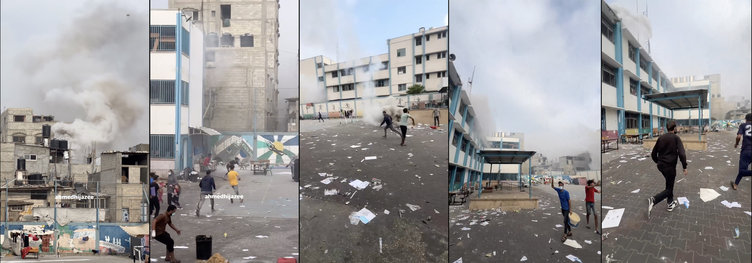
Screenshots from journalist Ahmed Hijazi’s story and video showing phosphorus bombs falling in “Abu Assi” School for Boys in al-Shati’. November 2023.
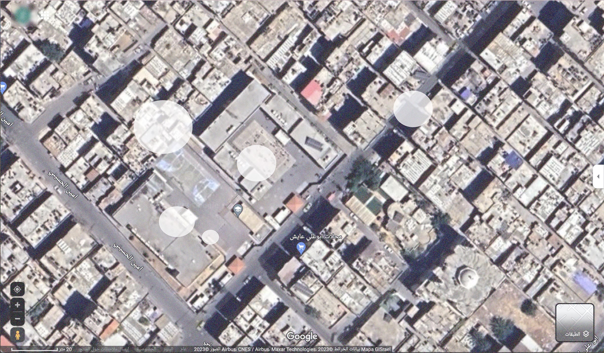
Screenshot of a satellite image on Google Maps showing “Abu Assi” School for Boys in al-Shati’. White circles explain where the bombs could have fallen, based on the visual content. November 2023.
A video posted by Dogukan shows one of the children who was killed in the attack; the skin burns on his hands and feet may have been caused by phosphorus bombs, which typically inflict similar wounds on the body. The same identifying wounds can also be seen on the bodies of the injured who were taken to hospital. We have not included these images in this report because of their graphic nature.
Amnesty International has provided evidence showing that the Israeli army used white phosphorus bombs during attacks on southern Lebanon, in the context of the ongoing war. This makes it possible that the Israeli military also used similar artillery smoke bombs when they targeted the UNRWA “Abu Assi School.” What also supports this is the comparable way that the shells exploded, the thick rising smoke in the targeted areas, and the burns that formed on the bodies of the victims and the injured after the attack.
Jabalia Elementary School for Girls (A&B) — “Abu Hussein School for Girls”
Social media users and news websites circulated reports of another attack on a different school on November 2, 2023. The first report of the attack appeared on X at 09:54 Gaza time. The X account Foad_Derbas published a post, accompanied by a video, claiming that “the occupation air force is targeting the UNRWA-affiliated Abu Hussein School, in the heart of Jabalia camp in northern Gaza.”
The Palestinian Ministry of Interior posted a video on Telegram that shows the first moments of the attack. Analyzing the shadow direction using the SunCalc tool suggests that the video was likely shot at 09:30 ±20 local time in Gaza City. This implies that the attack occurred between 9:10 – 9:54 on November 2, 2023, in the morning. The attack resulted in the killing of at least 20 people, with five others injured, according to UNRWA. The school in Jabalia refugee camp also sustained structural damage.
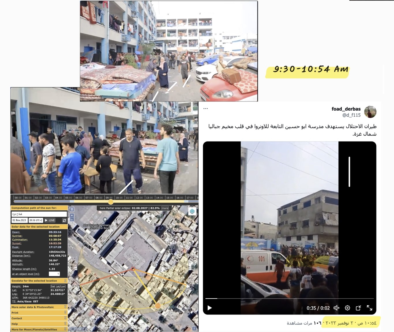
Time Analysis Documentation of the attack. Right: Two screenshots of Foad_derbas’ post on X. Left: Two screenshots from a video by the Palestinian Ministry of Interior and a shadow analysis of the shots using the Suncalc tool. The possible time of the attack is 9:30 - 9:54 in the morning of November 2, 2023.
Geographic Location
A search was conducted for the location of Abu Hussein School and the name “Jabalia Elementary School for Girls (A&B)” which appears in one of the videos. Visible elements matched those in a video published by the Sonar Media Center on November 2, 2023. Accordingly, the geographical location of Jabalia Elementary School for Girls (A&B) was identified. It is adjacent to Abu Hussein Elementary School for Boys in the Jabalia area of the Gaza Strip, at coordinates 31.537128, 34.498239.
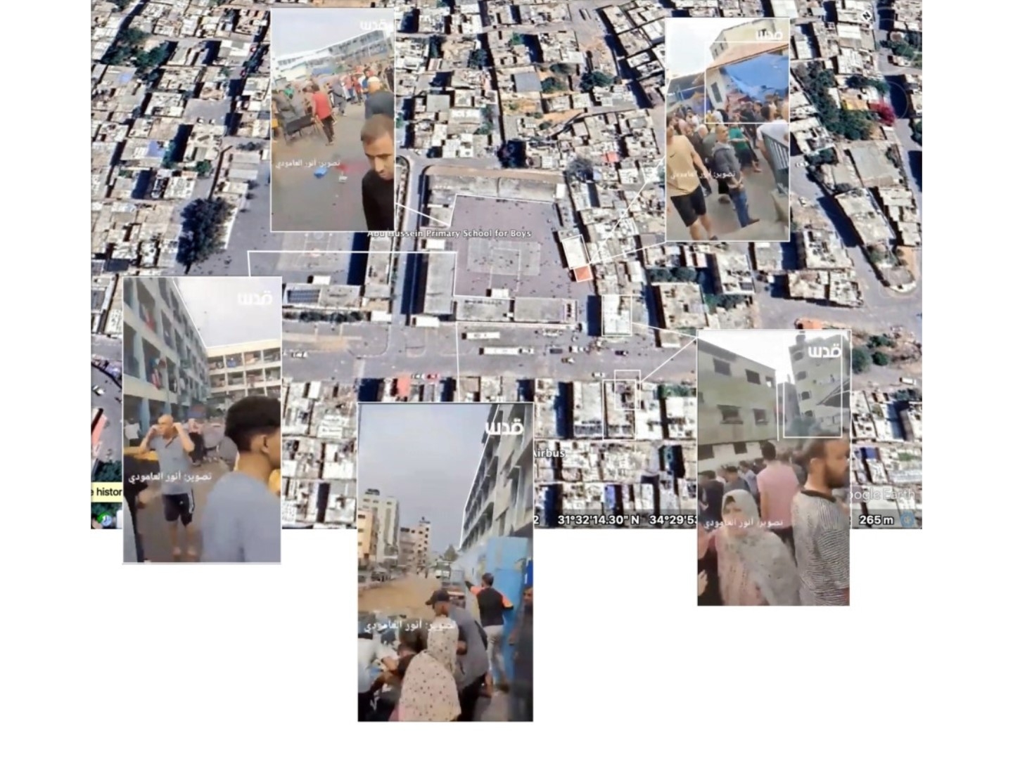
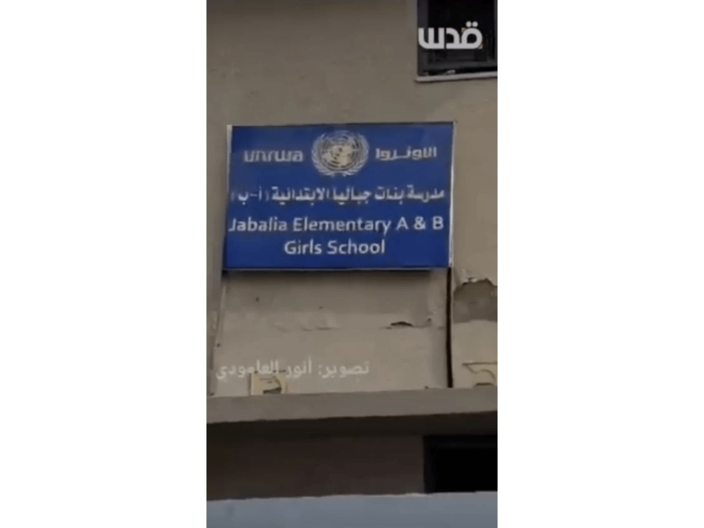
Image Comparison: A Google Maps satellite image shows the location of Abu Hussein School for Girls, along with stills from a video published by Sonar Media Center. November 2023.
The videos by Foad_derbas and Sonar Media Center are of the site in the first moments after the attack. They show civilians and emergency respondents gathered inside the school by the gate, where most of the victims were found at the time. Al Ghad channel reported from the site of the attack on the day after. In their video reportage, the channel interviewed a displaced civilian who was the father of one of the children killed in the attack. The father tells Al Ghad that shelling near the gate hit and killed his son. The same footage also shows the cavity that formed inside the school from the shell’s impact with the ground near the gate. Traces of the shelling are also noticeable in the shrapnel on the wall facing the cavity.
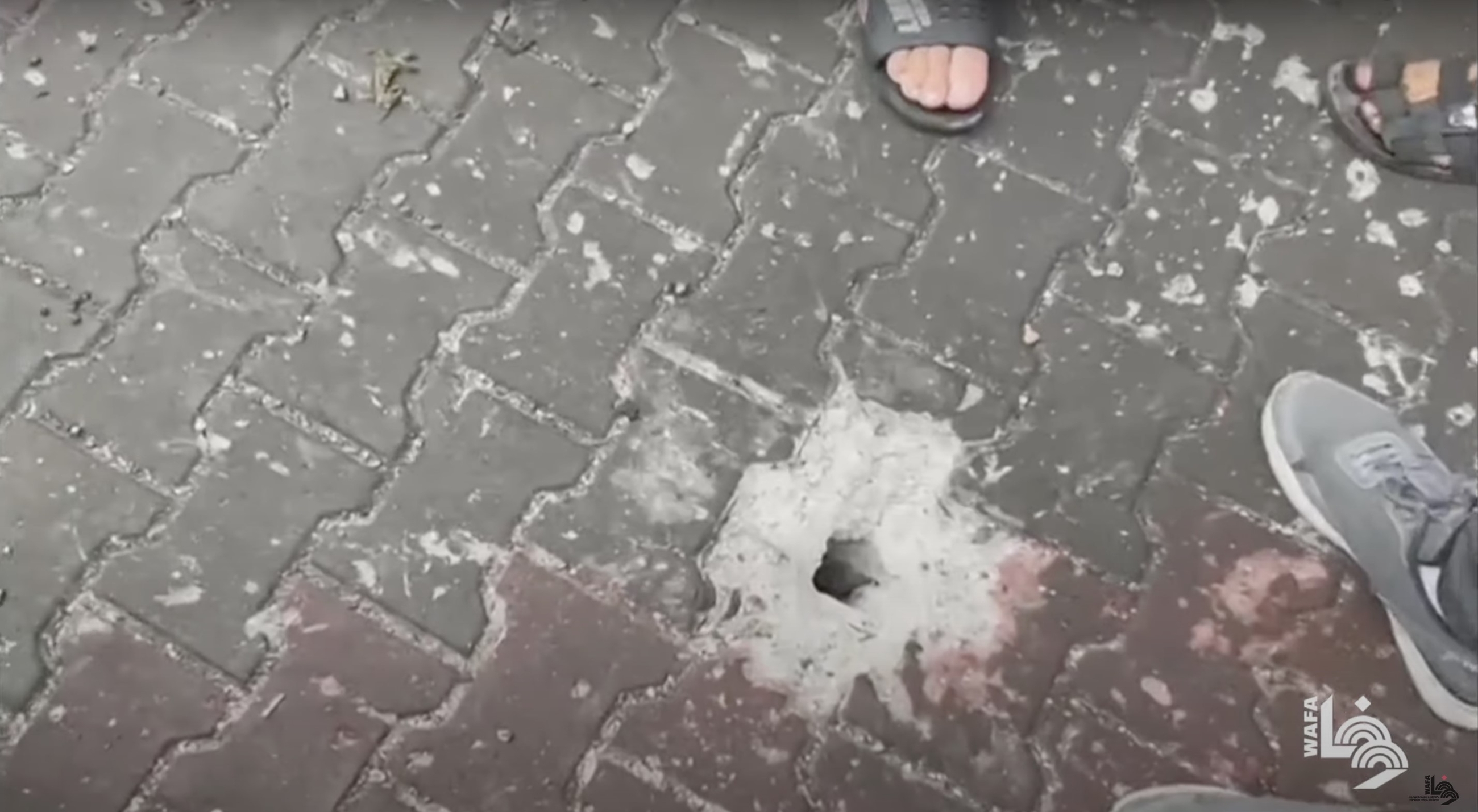
Documentation of the cavity formed by the projectile’s impact with the ground in the school. The image is a screenshot from a video on YouTube by WAFA Agency. November 2023.
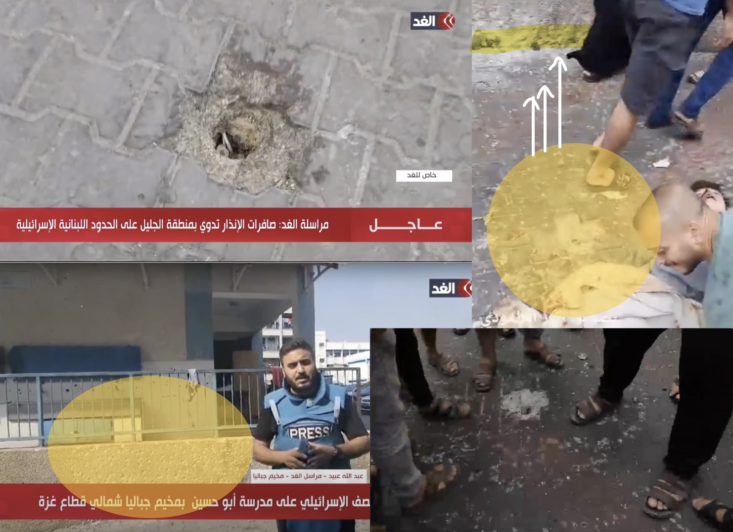
Screenshots showing the cavity that formed by the projectile’s impact with the ground in the school. Left: Images from the video of Al Ghad channel, taken the day after the attack. Top right: Screenshot from a video by Sonar Media Center. Bottom right: Screenshot from a video by Foad_derbas.
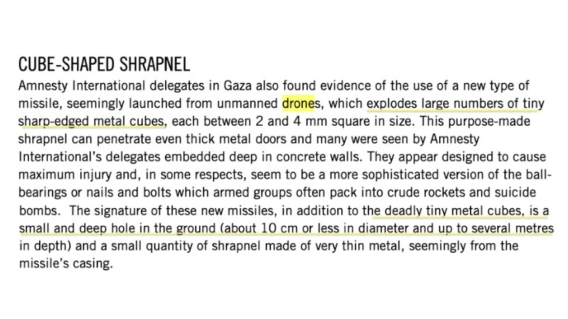
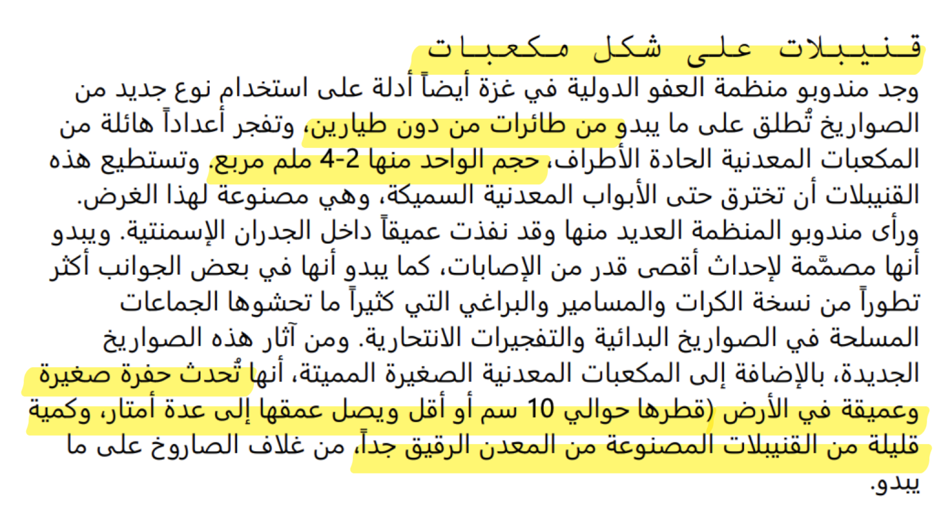
This type of cavity and shrapnel pattern may be formed by a 120mm-caliber shell upon impact at a 90-degree angle and a 360-degree shrapneling pattern. We were unable to specify the type of weapon used based on publicly available information since it was not possible to locate remnants of ammunition at the site. However, journalist Abdullah Obeid stated that an Israeli reconnaissance aircraft carried out the missile attack. This leads to the possibility that a new type of missile launched from Israeli unmanned aerial vehicles may be in use. Amnesty International has already documented the use of such missiles in Gaza, and refers to them having “cube-shaped shrapnel.” This type of missile explodes into several sharp-edged metal cubes and creates a small but deep crater with a diameter of 10 cm or less.
It is worth returning to the video from the Palestinian Ministry of Interior, which showed several severe bodily injuries that were not amputations. Most injuries appeared to be extensive wounds with heavy bleeding, which may confirm the use of this type of missile.
Osama bin Zaid School, al-Saftawi, Jabalia
On the following day, November 3, 2023, social media users and news sites circulated reports about another airstrike that targeted a school sheltering many displaced people in al-Saftawi. X user Israa was the first to post about the strike on X. At 19:27 local time in Gaza City, Israa posted: “May God take revenge on them; they are bombing a school [for the displaced] next to the hospital.”
At 20:22, another user posted about a “massacre at Osama bin Zaid School in al-Saftawi area.” Minutes later, at 20:35 local time in Gaza City, the official report from Al Jazeera was published on their Telegram account confirming that the attack killed several people and injured others.
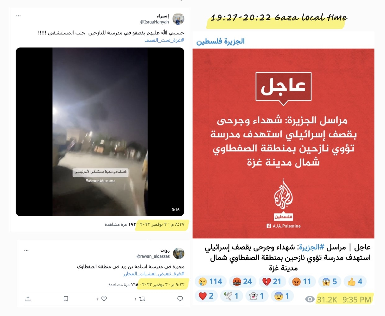
Time analysis documentation of the attack. Top left: A screenshot of the first post on X by Israa, reporting the bombing of a school sheltering the displaced. Bottom left: A post on X by Rawan, mentioning a “massacre in Osama bin Zaid School.” Right: A screenshot of the first official announcement of the attack on Telegram by Al Jazeera Palestine, estimating that the attack was carried out between 19:27 - 20:22 Gaza local time.
The time of the attack is estimated to be between 19:27 and 20:22 local time in Gaza City. The attack resulted in the killing of more than 20 people and injured dozens, according to the Palestinian Media Center and Al Jazeera.
Geographic Location
The geolocation of the attack was determined by matching visible elements in search results for the school’s name on Google Maps, with a live video on Al Jazeera from November 3, 2023, and photographs posted on the school’s Facebook page. Matching these visible elements made it possible to determine the geographical location of Osama bin Zaid Secondary School for Boys in the al-Saftawi area of Jabalia in the Gaza Strip, at coordinates 31.538148, 34.479256.
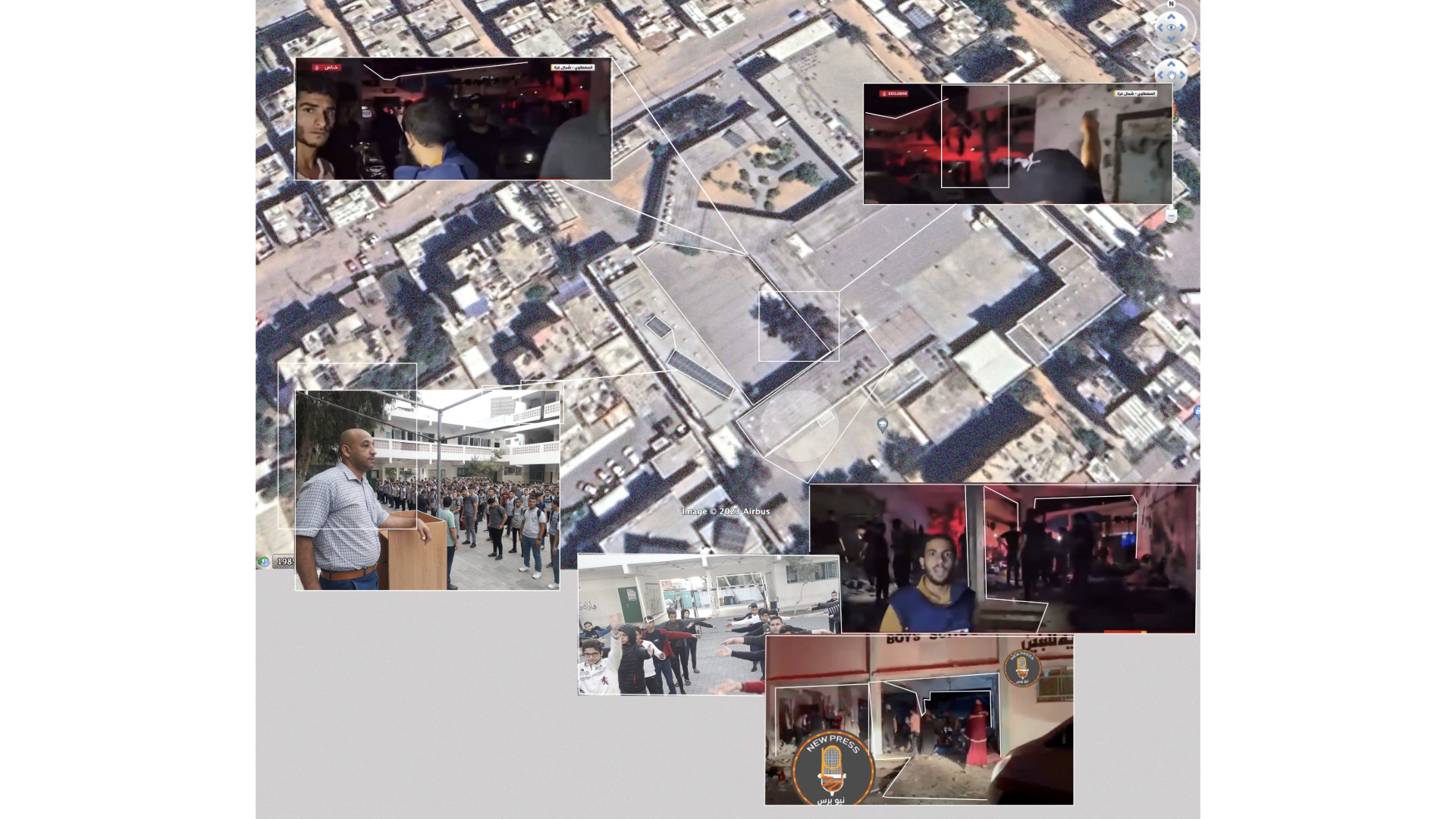
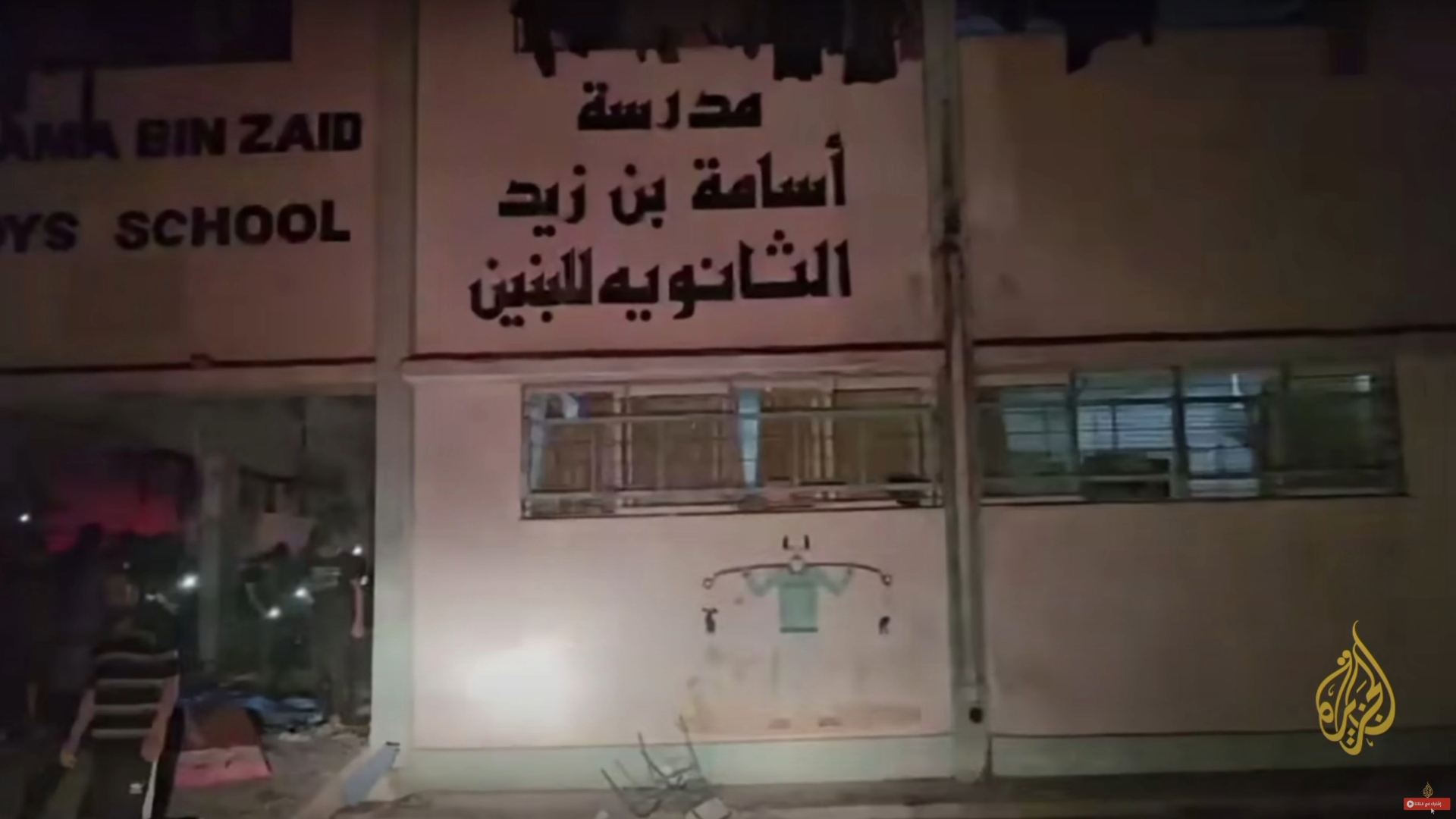
Image comparison: A Google Maps satellite image for the location of Osama bin Zaid School, shots from an Al Jazeera live video and another video by New Press from after the attack, and old photographs published on the Facebook page of the school. November 2023.
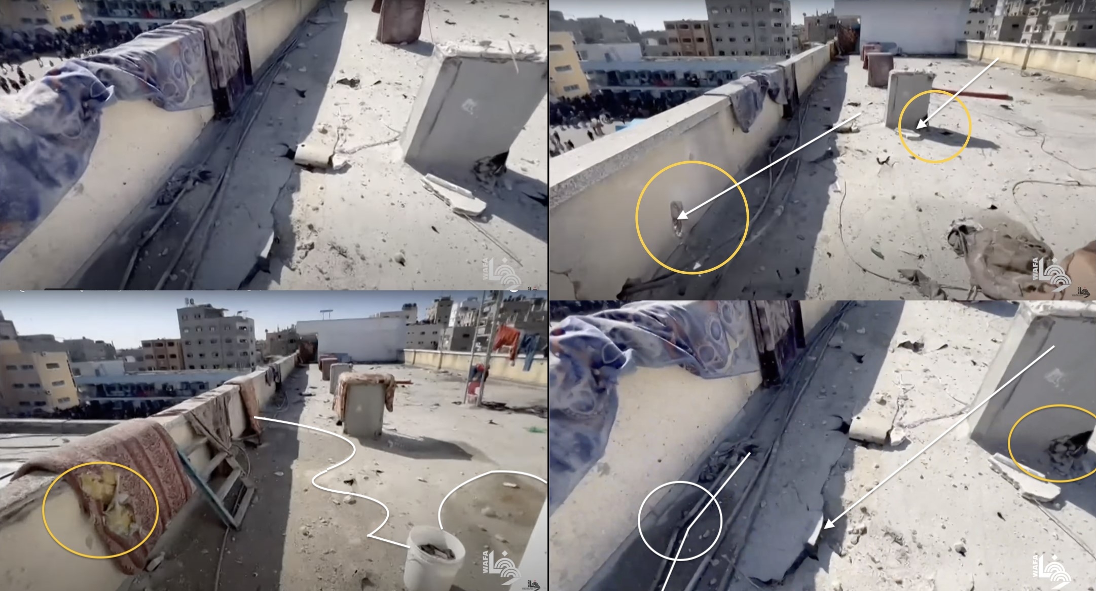
The shape and magnitude of the damage seen on one classroom wall, the wall facing it, and the ceiling above the classroom entrance, suggest that the school may have been directly bombed with a 122mm caliber projectile. The force of the projectile’s impact was strong enough to hurl the bodies up to 10 meters away from the site of impact. Shrapnel too is scattered within a 10-meter radius. The physical distribution of the casualties is visible in the video posted by the activist Hamza al-Masri.
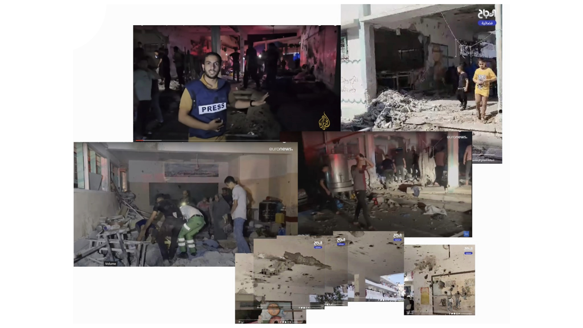
A collection of photographs showing the damaged school building, after the attack. By the entrance of a classroom, a wall was torn open, and traces of shrapnel are seen on the opposite wall and ceiling that leads to another torn wall. Photographs are taken from videos by Al Jazeera, euronews, and Al Najah Channel. November 2023.
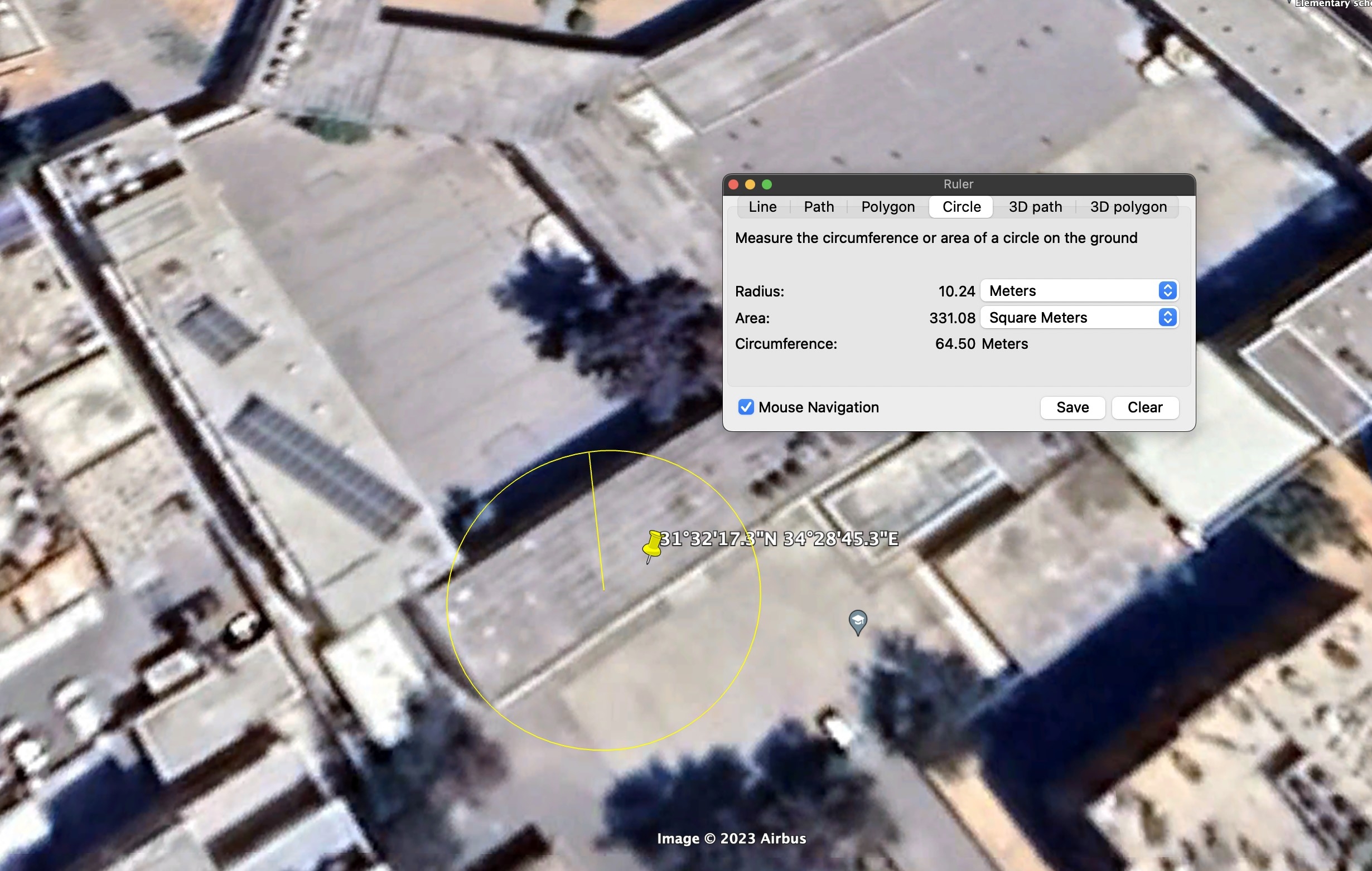
A screenshot of Google Earth Pro satellite image of Osama bin Zaid School’s location, showing where the projectile fell and its impact over a 10-meter radius. November 2023.
Al-Fakhoura Preparatory Boys School for Refugees, Jabalia
On November 4, 2023, the morning after the shelling of Osama bin Zaid School, social media users circulated reports about a new airstrike targeting an UNRWA school. An X account previously-named “Palestine Now” first reported the attack. Published at 09:50, the post stated: “Al-Fakhoura School in northern Gaza was targeted; a number of injuries were reported.”
The Palestinian Ministry of Foreign Affairs and Expatriates released a video on Facebook. Analysis of the shadows in the video suggests that it was filmed around 09:50 ±10 local time in Gaza City.
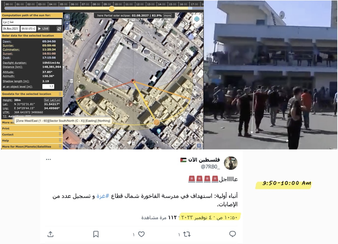
Time analysis documentation of the attack. Top Left: Still from a video by the Palestinian Ministry of Foreign Affairs and Expatriates on Facebook showing the shadow of someone in the courtyard after the attack. Top right: Image from the shadow analysis tool SunCalc. Below: Screenshot of the first report of the attack on X by the account Palestine Now.
The time of the attack can then be estimated to be between 09:50 and 10:00, on November 4, 2023. The attack killed 15 people and injured 70 others, according to the Palestinian Ministry of Health in Gaza.
Geographic Location
Geolocation was determined by matching visible elements in search results for “al-Fakhoura School” on Google Maps and two videos: an Al Jazeera live video, published following the attack on November 4, 2023, and a video posted by Palestine Today TV journalist Mohammed al-Najjar on TikTok. Accordingly, the geographic location of al-Fakhoura Preparatory School for Refugees on al-Shuhada’ Street in Jabalia in the Gaza Strip, was determined at coordinates 31.542273, 34.495187.
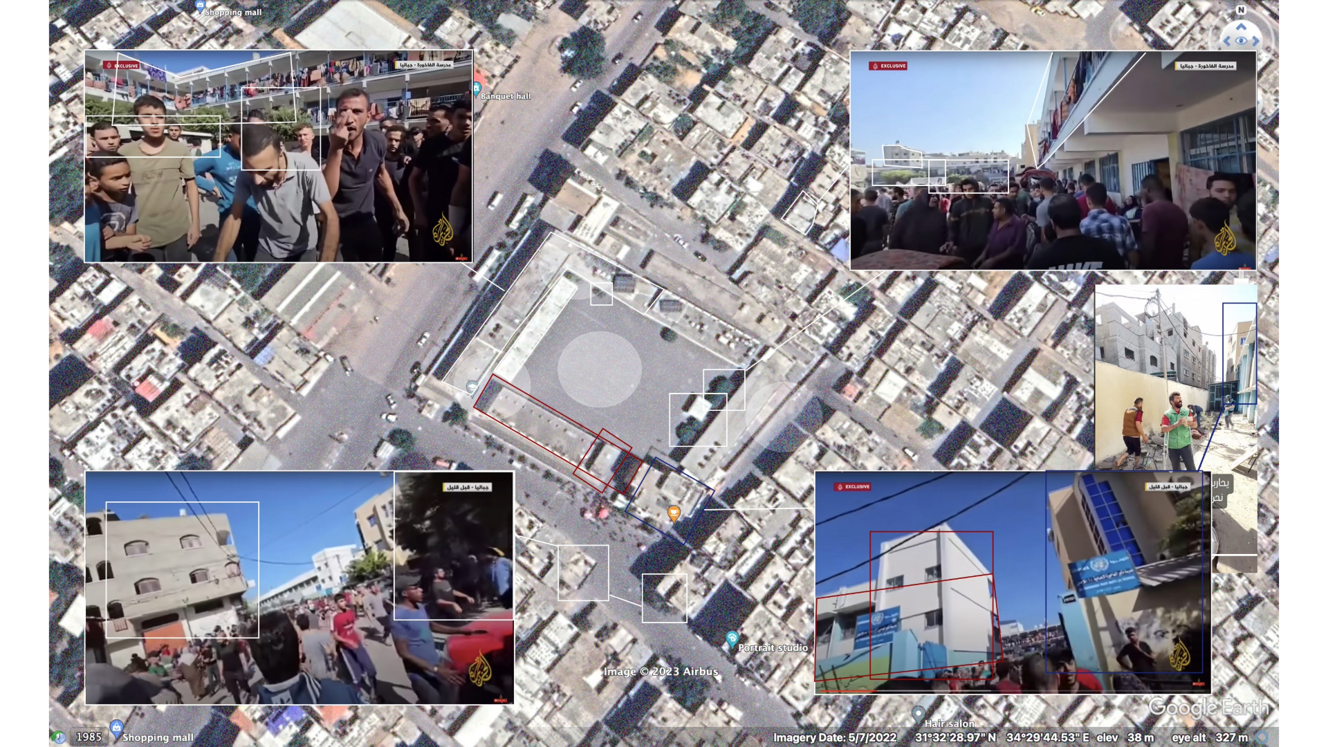
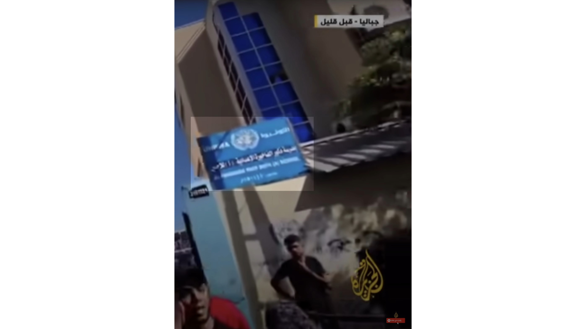
Image Comparison: A Google Maps satellite image of the School al-Fakhoura for Boys. Photographs are taken from Al Jazeera’s video. November 2023.
The Palestinian News and Information Agency (WAFA) published a video showing the damaged roof and water tubes in the school building. This explains why water is running down the open ceiling in one classroom, as seen in WAFA’s video and another video by Al Jazeera. The cavities on the roof are in the shape of a hollow square, and resemble, to some extent, roofs built from “hollow block slab,” which explains the fragments seen on the ground below the damaged roof.
Screenshots from a video by The Palestinian News and Information Agency on YouTube. The images show the damaged roof in one of the school buildings. The yellow circles represent holes that formed upon the projectile’s impact. The white arrows show the possible incoming direction of the projectile. The white lines clarify wet patches due to leading water, following the damage sustained by the water tubes. November 2023.
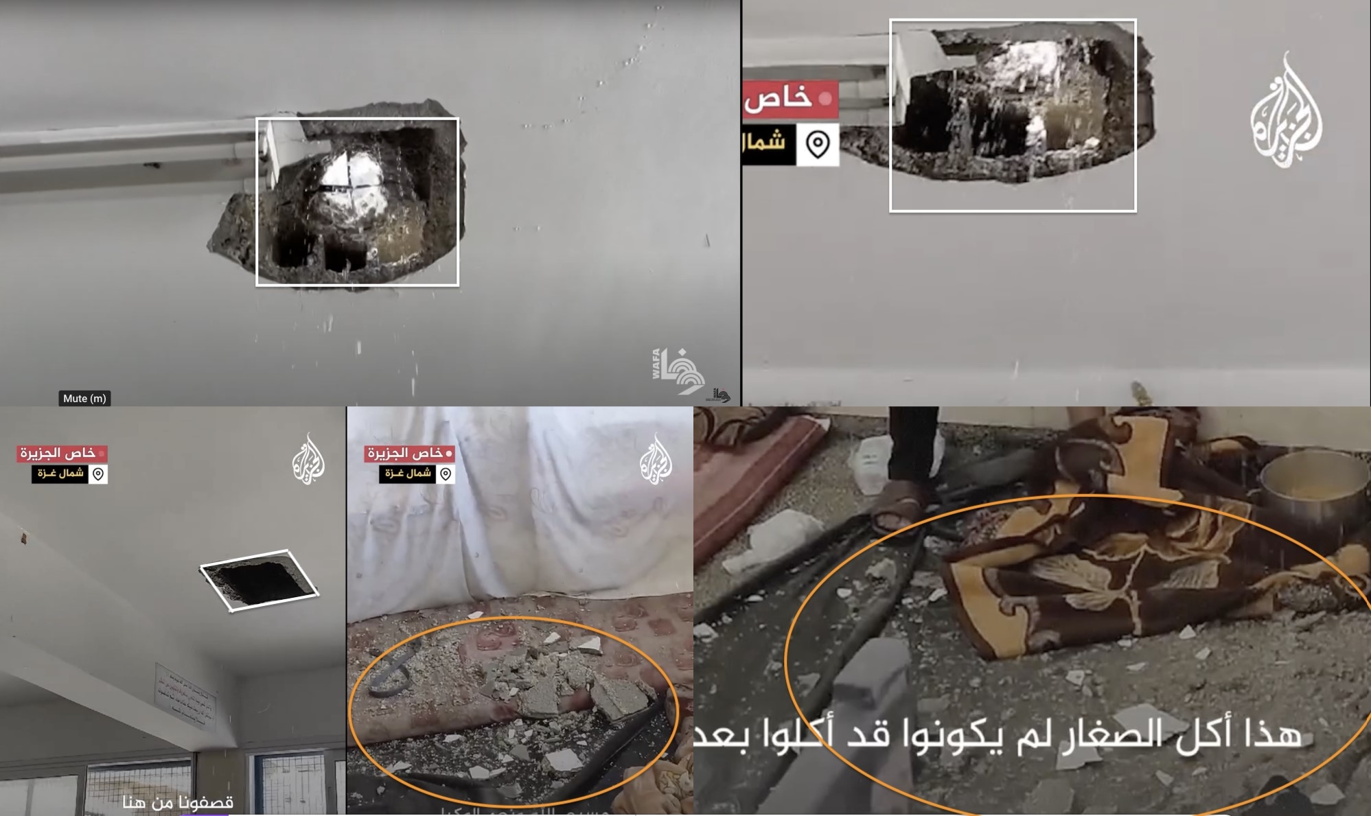
Top left: Image from a video by the Palestinian News and Information Agency on YouTube. The remaining shots are from a video by Al Jazeera on Facebook. These shots show two square cavities on the roof of a damaged classroom, following the attack. On the ground one notices that the material used to build the roof is fragmented, suggesting that it is “block.” Water is also dripping from the two cavities.
By closely examining the visual contents of publicly released videos by Al Jazeera, the Ministry of Foreign Affairs, and journalist al-Najjar (video 1 and video 2), and by listening to eyewitness accounts — including that of a child who witnessed the attack — and analyzing the direction of the incoming projectiles and their damage formation, it can be concluded that the attack involved several Israeli artillery shells. Some of these shells hit the rear end of the school designated for “food preparation and bread baking for refugees.” Other shells struck the school building, piercing the roof of a classroom that was used as a shelter for the displaced. More shells landed in the inner courtyard of the school, and one of them “hit the tent of a displaced person.”